

Our Experience
SCDOT Port Terminal Access Road Project
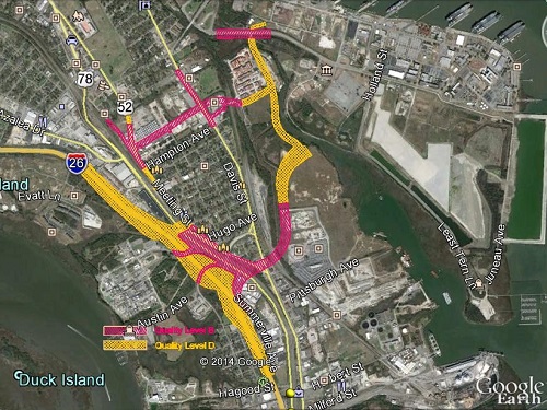
GEL Solutions performed a Quality Level B SUE Investigation for the SCDOT Port Terminal Access Road project in support of the proposed South Carolina Ports Authority’s new 280-acre facility.
The Challenge
GEL Solutions was tasked with designating and mapping subsurface utilities and aerial lines for the South Carolina Department of Transportation's (SCDOT) Port Terminal Access Road project. The SUE survey covered all areas potentially impacted by the new access roads to the South Carolina Ports Authority’s future 280-acre facility on the Cooper River.
GEL Services Provided
Under our existing SUE on-call contract with SCDOT, GEL Solutions performed a Quality Level B SUE investigation and power pole inventory to provide existing utility information to potential Design/Build teams for the future Port Access Road on I-26 (Exit 217) located in Charleston County, South Carolina. Areas with major impacts were surveyed to Quality Level B standards in accordance with ASCE 38-02 and peripheral areas were mapped to Quality Level D standards. Over 100,000 linear feet of underground utilities and over 40,000 linear feet of aerial facilities were mapped. Utilities involved in this investigation included electric power, natural gas, water, sanitary sewer, fiber optic, cable television, and telephone.
The Result
This project was completed on an expedited schedule and under budget. Comprehensive Quality Level B maps were developed in Microstation (V8i) format in accordance with SCDOT’s “CADD Guidelines for SUE Consultants” and submitted to SCDOT. The maps were used to facilitate the Design/Build Development and Procurement process for SCDOT. Upon completion of the project, the SCDOT Project Manager performed an evaluation of our services and awarded GEL Solutions with a perfect score (500 out of 500).